


Red Level City Hall, Covington County, Alabama
About
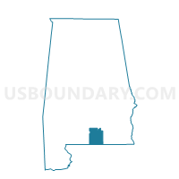
Outline

Summary
| Unique Area Identifier | 521548 |
| Name | Red Level City Hall |
| County | Covington County |
| State | Alabama |
| Area (square miles) | 24.31 |
| Land Area (square miles) | 24.28 |
| Water Area (square miles) | 0.03 |
| % of Land Area | 99.87 |
| % of Water Area | 0.13 |
| Latitude of the Internal Point | 31.41582770 |
| Longtitude of the Internal Point | -86.64179210 |
Maps

Graphs
Select a template below for downloading or customizing gragh for Red Level City Hall, Covington County, Alabama


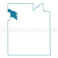
Neighbors
Neighoring Voting District (by Name) Neighboring Voting District on the Map
- Beat 8 FD, Conecuh County, AL
- Buck Creek-Brooks, Covington County, AL
- Loango, Covington County, AL
- River Falls City Hall, Covington County, AL